Taking a break on the shore of Falls Lake | Photo © Rebecca Walling
Segment 10: Eno River & Falls Lake
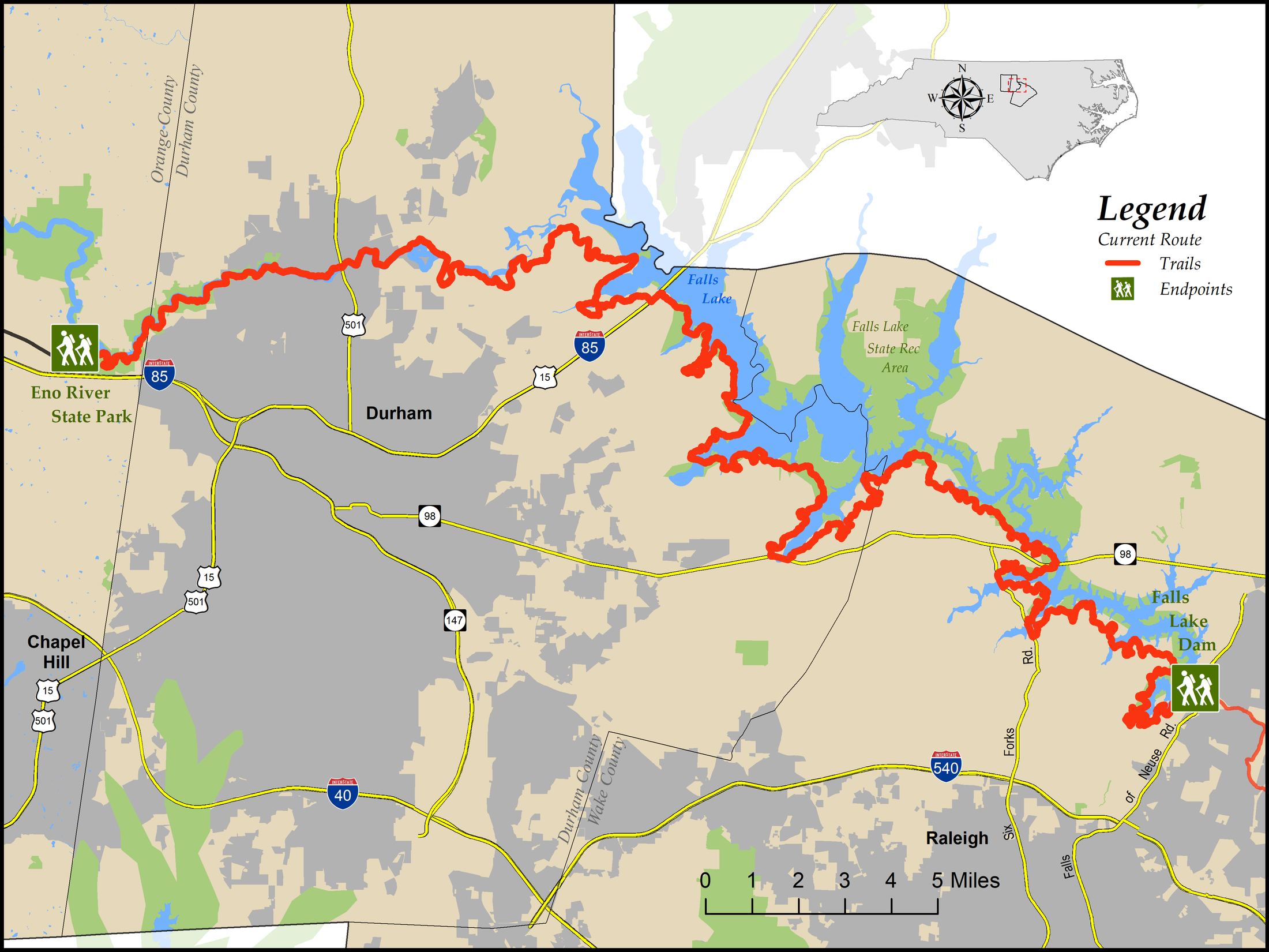
Eno River State Park to Falls Lake Dam
Distance: 78.6 miles, essentially all on trail, with a few incidental road sections
- Difficulty:
 to
to 
Most elevation gain/loss is in Eno River State Park Check Trail Updates before starting your hike. To receive email notifications of new trail updates, click here and subscribe to “Trail Updates.”
If you find hazardous conditions or maintenance needs along the trail, please notify us using the form at mountainstoseatrail.org/the-trail/trail-issues.
In the eastern portion of Segment 10 along Falls Lake, the MST is often close to the water, and when lake levels are high, low-lying sections of the trail may be flooded. To determine whether a particular trail section is passable at current water levels, check out our guide to trail elevations and water levels.
 Art Kelley’s beautifully detailed maps of the Falls Lake and Eno River trails are available for purchase through his website, artshikingmaps.info.
By Mark Edelstein and Friends of the Mountains-to-Sea Trail
Water, water everywhere, to paraphrase Coleridge, could be the theme for this segment of the Mountains-to-Sea Trail (MST) in North Carolina’s Piedmont. As it winds its way along two prominent bodies of water, the Eno River and Falls Lake, it is hard to believe that just south of you is one of the most populated areas in the state, the Triangle (Raleigh, Durham, and Chapel Hill). While there are certainly brushes with “civilization,” the majority of this trail corridor harks back to a time when this state was famous for its rural qualities.
Heading east, the trail starts in Orange County, following the Eno downstream in Eno River State Park to soon enter Durham County, where it goes through history-laden West Point on the Eno. Approximately 5 miles later, you traverse Penny’s Bend Nature Preserve, where a geological oddity causes the river to form a U-shaped bend, unusual for this area. Soon the Eno disappears as it flows into the vastness of Falls Lake. The MST now hugs the southern shore of this man-made reservoir as it winds its way in and out of coves and small creeks to end by the dam on the outskirts of Raleigh. The fact that this 79-mile footpath exists is due to a combination of serendipity and hard work: serendipity because of the creation of several large parcels of adjoining public lands, rare in North Carolina east of the mountains, and hard work due to all the Triangle-area trail enthusiasts who’ve made this footpath a reality.
Highlights Include
- The Eno River has its beginnings in Orange County and extends 33 miles to where it joins with the Flat River to become the Neuse and empty into Falls Lake. This swift, mostly shallow stream with a few deep spots (such as Sennett Hole) was named after the Eno Indians who lived along its banks prior to European arrival. Settlers first came to the area in the mid-1700s establishing farms and gristmills. The last of these mills ceased operation by the 1940s. The remains of several mill operations can be glimpsed today. Other remnants of years past are the Durham Pump Station and the Eno Quarry. The latter is especially scenic and a great spot to idle. The bluffs traversed in the state park give the path a mountainous feel. The river itself is known for its beauty and water quality. Over 5,600 acres of land have been protected in the Eno Basin including the state park, West Point on the Eno, and Penny’s Bend.
- Falls Lake is a 12,410-acre lake surrounded by 25,500 acres of public land situated in Durham, Wake, and Granville Counties. Construction of the dam that holds the lake was started in 1978 and completed in 1981. The lake provides drinking water for several of the surrounding communities, including the city of Raleigh, aids with flood control, and serves as a recreation area and wildlife habitat. The MST runs about 60 miles along the lake’s southern edge. Besides providing outstanding lake views, the trail informs the hiker of the area’s pre-lake existence during encounters with multiple old road grades and the remains of several homesites and farms.
- Segment 10 includes eight crossings of the historic route of Fish Dam Road, which began as an American Indian trading path and saw continuous use until the twentieth century (see our Fish Dam Road page for more information).
- From near Penny’s Bend Preserve to the Little Lick Creek crossing, 23.3 miles, the MST is located on land that was once part of the Bennehan-Cameron family plantation holdings. Beginning in 1771, these related families controlled several plantations totaling about 30,000 acres, including what is now the Historic Stagville State Historic Site, and exploited the labor of over 1,000 enslaved people to become among the wealthiest families in antebellum North Carolina. See historicsites.nc.gov/all-sites/historic-stagville for more information about the plantations and the enslaved people who lived there.
Elevation
Segment 10 Eastbound Elevation Profile

Day Hikes
Falls Lake Day Hikes
Day Hike A: Falls Lake Dam
Falls Lake Tailrace at Falls of Neuse Road to Raven Ridge Road
Distance: 3.6 miles
Day Hike B: Raven Ridge Ramble
Raven Ridge Road to Dead End of Possum Track Road
Distance: 2.6 miles
Day Hike C: Possum Track Travels
Dead End of Possum Track Road to Possum Track Road
Distance: 3.0 miles
Day Hike D: Flipped Car
Possum Track Road to Bayleaf Church Road
Distance: 3.0 miles
Day Hike E: Six Forks-Bayleaf Connector
Bayleaf Church Road to Six Forks Road
Distance: 1.2 miles
Day Hike F: Blue Jay Point
Six Forks Road to Six Forks Road
Distance: 3.1 miles
Day Hike G: Barton Creek
Barton Creek Boat Ramp off Six Forks Road to NC 98
Distance: 2.3 miles
Day Hike H: Shinleaf
N.C. 98 to Shinleaf Recreation Area
Distance: 3.0 miles
Day Hike J: The March to Headquarters
Shinleaf Recreation Area to NC 50
Distance: 3.9 miles
Day Hike K: The Long Haul
NC 50 to NC 98
Distance: 7.2 miles
Day Hike L: Rambling to Rolling View
NC 98 to Rolling View Recreation Area
Distance: 3.4 miles
Day Hike M: Rolling View to Little Lick Creek
Rolling View State Recreation Area to Little Lick Creek Bridge
Distance: 4.4 miles
Day Hike N: Little Lick Creek
Midpoint of Little Lick Creek Bridge West to Cheek Road
Distance: 4.4 miles
Day Hike P: Hickory Hill Boat Ramp
Cheek Road to Hickory Hill Boat Ramp
Distance: 4.9 miles
Day Hike Q: High Flying, Fast Driving
Hickory Hill Boat Ramp to Redwood/Tom Clark Roads
Distance: 2.3 miles
Day Hike R: The Swamp Connection
Redwood & Tom Clark Roads to Red Mill Road (South of Ellerbe Creek)
Distance: 0.9 mile
Day Hike S: RMR2 (Red Mill Road — Twice!)
Red Mill Road (North of Ellerbe Creek) to Red Mill Road (South of the Eno River)
Distance: 4.6 miles
Day Hike T: End of the Line (or the Beginning)
Red Mill Road to Penny’s Bend
Distance: 4.2 miles
Eno River Day Hikes
Day Hike 1: West Point on the Eno City Park
US 15/501 to Guess Road, Durham
Distance: 1.6 miles, plus 0.1-mile connector trail
Day Hike 2: Laurel Bluffs
Guess Road to Pump Station Access off Rivermont Road
Distance: 2.6 miles, plus 0.3-mile connector trail
Day Hike 3: Pump Station to Cabe Lands
Pump Station Access off Rivermont Road to Cabe Lands Access off Howe Street
Distance: 3.5 miles plus 2 connector trails, one 0.3 mile and one 0.2 mile
Day Hike 4: Cabe Lands Access to Pleasant Green Access
Howe Street West of Sparger Road to Pleasant Green Road
Distance: 2.5 miles, plus 0.2-mile connector trail
Photos