By Jim Grode and Friends of the Mountains-to-Sea Trail
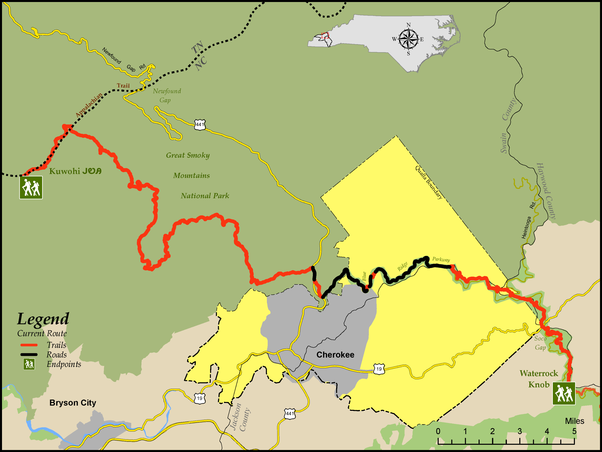
The 46.8-mile-long Segment 1 of the Mountains-to-Sea Trail (MST) begins in Great Smoky Mountains National Park (GSMNP), straddling Tennessee and North Carolina. Newfound Gap Road (US 441), which travels north from Cherokee, North Carolina, to Gatlinburg, Tennessee, forms the backbone of the park and climbs to over 5,000 feet at Newfound Gap.
If national parks have specialties, the Smokies is known as a hiker’s park. The scenery is diverse: mountain views, old-growth trees, waterfalls, streams, and more shades of green than a paint chart. Mile for mile, you’ll find hiking in the park easier than in the neighboring national forests. Even though there are no blazes on Smokies trails, they are so well marked at every intersection that you can follow them with confidence. (Still, stop at a Visitor Center and pick up a Great Smoky Mountains Trail Map for $1.00.)
The Smokies may be the most visited national park in the country but only the roads and parking lots are congested. With over 800 miles of trails, even popular trails are not very busy. The trails in the Smokies are well maintained and well marked. Hikers will appreciate that they’re in a national park. The Smokies, in a temperate rainforest, have a great variety of wildflowers, from the first bloodroot in March to the last asters in October, as well as more tree species than all of Europe. But hikers will also see the richness of the community life that was here before the area became a national park in 1934.
This segment also highlights the southernmost part of the Blue Ridge Parkway (BRP). Also administered by the National Park Service (NPS), the BRP runs 469 miles from GSMNP to Waynesboro, Virginia, and receives more visitors each year than any other NPS unit. It is a marvel of Depression-era (and later) engineering, and the MST roughly parallels it through the mountains.
Heading eastbound, the MST starts at the observation tower on top of Kuwohi in GSMNP, on “top of old Smoky” at the state boundary. Kuwohi was previously known as Clingmans Dome, and in 2024, its original Cherokee name (meaning “mulberry place”; ᎫᏬᎯ in the Cherokee syllabary) was officially reinstated. After paralleling the road to Kuwohi for a few miles, it heads deep into the woods on the longest roadless stretch of the MST—22.8 miles with no road access. Emerging to US 441 at Mingus Mill, the segment continues past the GSMNP’s Oconaluftee Visitor Center and Mountain Farm Museum and along the Oconaluftee River, popular for tubing.
From here, the trail continues along the shoulder of the BRP for several miles, with two short trail sections to avoid tunnels (in which walking is prohibited). The BRP is famous for the views from its overlooks, and this segment features several. Turning to gravel roads, the route continues through the Qualla Boundary, home of the Eastern Band of Cherokee Indians, before returning to hiker-only trail for the last 6.4 miles to Waterrock Knob.
Highlights Include
- The observation tower atop Kuwohi, at 6,643 feet the highest point in GSMNP, where you can see seven states on a clear day (although, sadly, pollution often limits visibility to 20 miles or less)
- Walking along Deep Creek, with its cascades and rock falls
- Campsite #57, Horace Kephart’s last camp, and the historic millstone put up in his memory
- Historic Mingus Mill, built in 1886 and still in operation; tours are available
- The cultural and natural history exhibits at the Oconaluftee Visitor Center and Mountain Farm Museum
- The 0.3-mile side hike to the summit of Waterrock Knob, the third-highest point on the MST, where views on a clear day can encompass four states
- In 2023, students from Elizabeth City State University, a Historically Black University, embarked on the North Carolina leg of the Lenovo Work For Humankind project. With the help of a van loaded with state-of-the-art Lenovo tech, they took their studies on the road to Cherokee, where students hiked the first segment of the Mountains-to-Sea Trail while documenting key points of interest. Afterwards, Motorola built an app documenting the trip, with displays in Cherokee and English. Find out more and download the app here.
Elevation
Segment 1 Eastbound Elevation Profile


