A Sampson County farm | Photo © Donna Bailey-Taylor
Segment 12: Agricultural Heartland
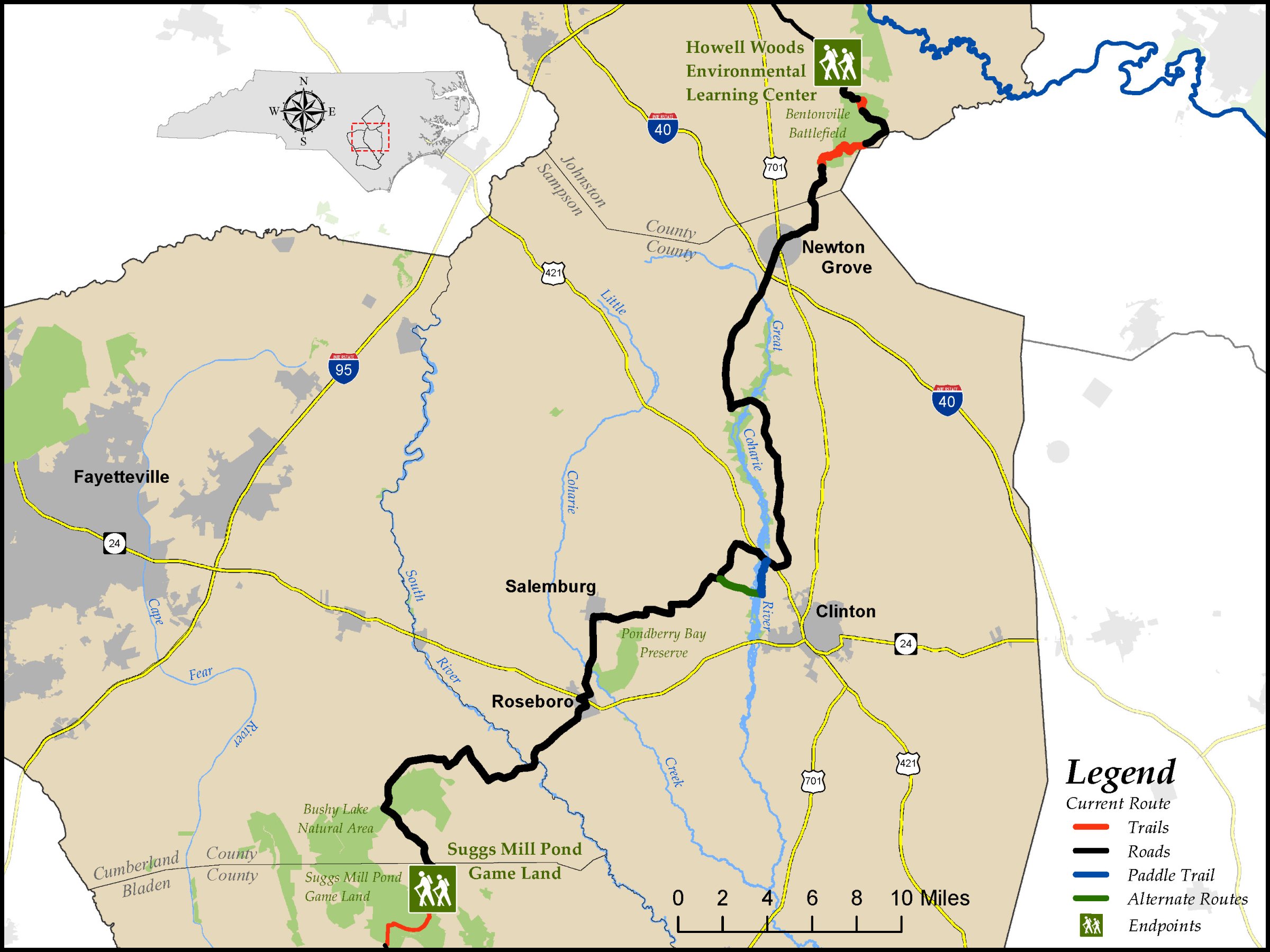
Howell Woods Environmental Learning Center to Suggs Mill Pond Game Land
Distance: 66.2 miles (4.8 on trail, 61.4 on road; alternate paddle route is 2.2 miles on river and 2.1 miles on road, replacing 3.5 miles of road on the primary route)
Difficulty:

Trail Communities: Newton Grove, Roseboro
Check Trail Updates before starting your hike. To receive email notifications of new trail updates, click here and subscribe to “Trail Updates.”
If you find hazardous conditions or maintenance needs along the trail, please notify us using the form at mountainstoseatrail.org/the-trail/trail-issues.
By Kate Dixon, Jim Grode and Friends of the Mountains-to-Sea Trail
This 66-mile segment traverses one of the most productive agricultural areas in North Carolina. It passes through Bentonville Battlefield, the site of the largest Civil War battle in the state, crosses three popular paddling rivers, and goes through two of Sampson County’s picturesque small towns.
The farms of Johnston, Sampson, and Cumberland Counties along the route produce a diversity of products. As you walk, look for tobacco, cotton, sweet potatoes, hogs, turkeys, cattle, soybeans, and forestry. Great agricultural soils and climate, fairly flat topography, and good rainfall have led Sampson County to be ranked first in North Carolina in agricultural crops and second in livestock and poultry, and the areas you will visit in southern Johnston and eastern Cumberland Counties produce similar crops in abundance.
This segment is a great place to explore by bike as well as on foot because all but 4.8 miles of the primary route is still on paved roads.
In addition, an alternative route provides eastbound hikers an opportunity to complete part of the segment by canoe or kayak on the Great Coharie River.
Highlights Include
- The 2,800-acre Howell Woods Environmental Learning Center in the vast Neuse floodplain. Sometimes called the Let’Lones, this is the western end of Segment 12.
- Bentonville Battlefield, now a North Carolina historic site. The trail route takes you through fields and forests, past historical displays that help you envision the battle as it unfolded in March 1865. A history of the enslaved population on several plantations on or near the historic site is available on the Friends of Bentonville Battlefield website at fobbnc.com/it-was-home.
- The Great Coharie River and Little Coharie Creek, named for the Native American tribe that is still based in Sampson County today. Look for the bridges crossing these popular paddling destinations or take advantage of the paddle option on the Great Coharie.
- The 2,100-acre Pondberry Bay Plant Conservation Preserve between Roseboro and Salemburg, which is being managed to enhance habitat for rare and endangered native plants and wildlife. The trail route follows the roads around this preserve.
- The town of Newton Grove, first incorporated in 1879, grew up to serve the vibrant farming community in that area.
- Roseboro, incorporated in 1891, was built along the Cape Fear and Yadkin Valley Railroad line, which ran from Fayetteville to Wilmington. The MST runs directly through downtown along a brick pathway built by Friends of the MST. Along the brick pathway, an MST-themed public art installation featuring the paintings of Autumn Cobeland (learn more at autumncobelandpaintings.com) has beautified utilitarian electrical boxes. In addition, many of the bricks of the pathway are engraved to memorialize some of the notable residents, businesses and community groups of Roseboro’s past and present as well as members of the MST community.
- The South River, a blackwater river, famed for paddling. Look for the bridge crossing over this beautiful river at the Sampson/Cumberland county line.
- Bushy Lake Natural Area, part of the NC state parks system, which is located along the trail route on Gip and Turnbull Roads in Cumberland County. Look for the kiosk at an entrance into the natural area on Turnbull Road.
Photos