Pea Island Dunes | Photo © Paul Travis
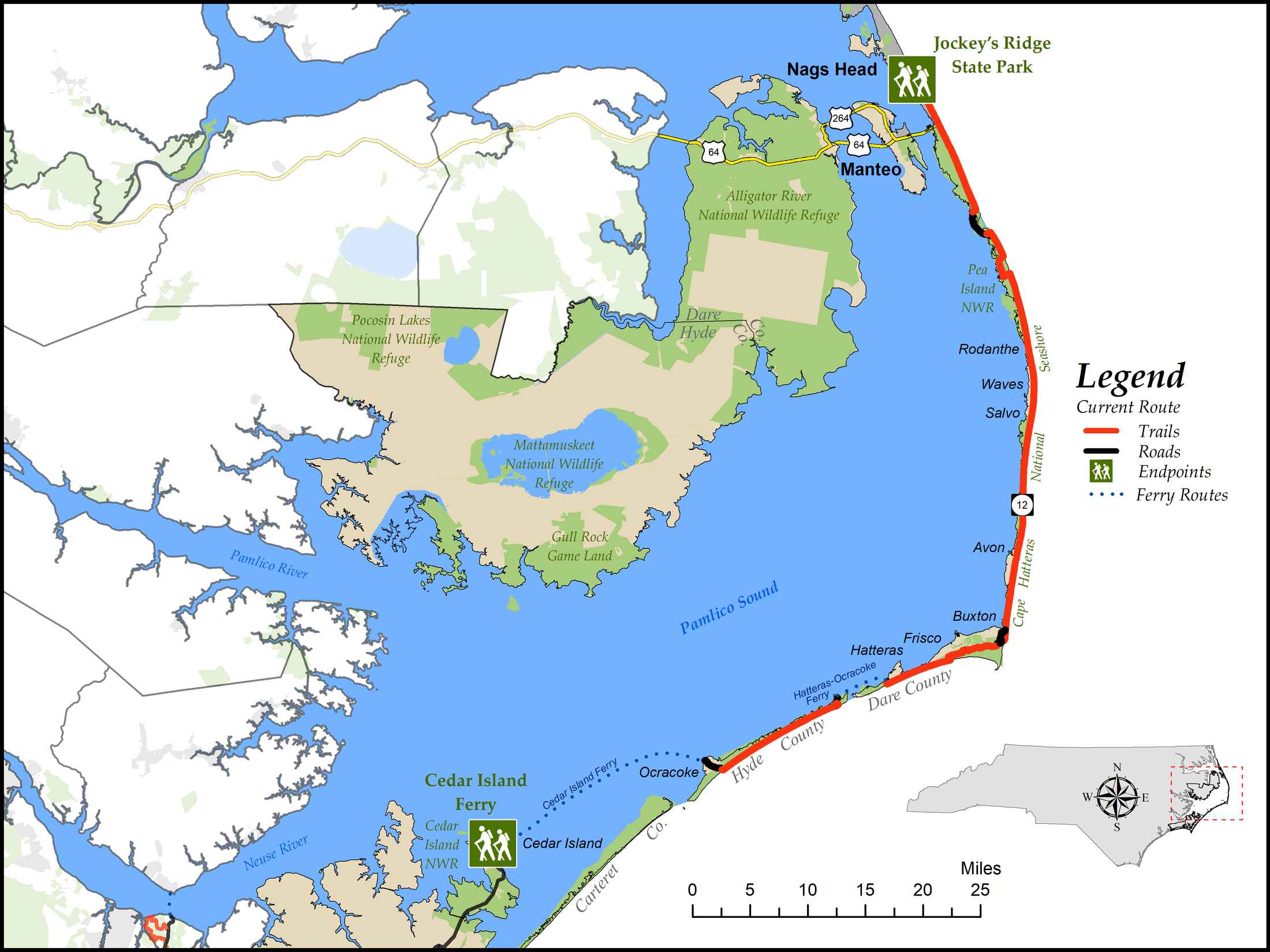
Segment 18: The Outer Banks
Cedar Island Ferry to Jockey’s Ridge State Park
Distance: 82.0 miles of hiking (65.3 on beach, 9.1 on other trails, and 7.6 on roads), plus two ferry rides, one 2½ hours long and one 60 minutes long
Difficulty:

Although the trail is flat, much of the walking is on loose sand, which can be tiring.Trail Communities: Ocracoke, Hatteras, Frisco, Buxton, Avon, Salvo, Waves, Rodanthe, Nags Head
Check Trail Updates before starting your hike. To receive email notifications of new trail updates, click here and subscribe to “Trail Updates.”
If you find hazardous conditions or maintenance needs along the trail, please notify us using the form at mountainstoseatrail.org/the-trail/trail-issues.
By Jim Grode and Friends of the Mountains-to-Sea Trail
From the secluded beaches of Ocracoke Island to the tourist bustle of Nags Head, this segment captures the many aspects of North Carolina’s easternmost parts. These barrier islands, or “banks,” are rich with history, wildlife, and scenery. They are also the site of some of the most extreme weather in the country. Situated as it is—sticking far out into the ocean, where two major ocean currents collide—the region has earned its nickname, “The Graveyard of the Atlantic.”
The western end of this segment is at the Cedar Island ferry terminal in Carteret County and the eastern end is at the highest point on the dunes at Jockey’s Ridge State Park in Dare County. On the approach to the highest dune is the new monument erected by Friends to mark the trail’s eastern terminus.
The segment includes 82.0 miles of trail plus two ferry rides. The ferry between Cedar Island and Ocracoke Island takes about 2½ hours, and the ferry between Ocracoke and Hatteras Island is about 60 minutes.
Because most of the trail in this segment is on loose, sandy beaches, it is not recommended for bicycles.
Because most of the trail in this segment is on loose, sandy beaches, it is not recommended for bicycles; however, NC 12 parallels the trail almost its entire length and is a good alternative for cyclists.
Highlights Include
- Ocracoke Village, a quaint and quiet town at the western end of the segment
- Cape Hatteras National Seashore, encompassing the beaches for nearly the entire segment
- The Ocracoke pony pens, which hold the descendants of a horse herd that once roamed on the island
- The Graveyard of the Atlantic Museum, which tells the story of the over 2,000 shipwrecks off the coast of North Carolina
- At the museum, a monument commemorating the Hotel De Afrique, lodging for African Americans fleeing slavery during the Civil War. It was considered the first safe place for people escaping slavery and is officially recognized as part of the Underground Railroad Network to Freedom.
- The Open Ponds Trail, a sandy track through maritime forest near Buxton Woods
- Cape Hatteras Lighthouse, at 208 feet the tallest brick lighthouse in North America, and the most recognized symbol of the Outer Banks. It is open for climbing in the summer.
- The historic Chicamacomico Life-Saving Station, the original site of the forerunners to the US Coast Guard, which is now a museum
- Pea Island National Wildlife Refuge, a renowned haven for waterfowl, especially in the winter
- The historic Oregon Inlet Life-Saving Station
- Jennette’s Pier in Nags Head, a 1,000-foot fishing pier originally built in 1939 and reconstructed several times, most recently in 2011, which is now part of the North Carolina Aquarium
- Jockey’s Ridge State Park, the largest and highest dune complex in the eastern United States and site of the MST eastern terminus monument
Photos