

In several locations across the state, additional trail has officially been designated as part of the MST. Three are located in cities along the Neuse River corridor, which is the original planned route of the MST and is approximated by the Neuse River Paddle Route (Segments 11A-16A). A fourth section is in Morehead City.
These sections are spaced far apart, with long, and unsafe or unpleasant, road connections, so we do not currently include them in our cross-state route. We and our partners are continually working to expand trail, and ultimately we hope to incorporate these and other sections into a connected route.
Meanwhile, these sections are enjoyable in their own right, and we encourage people to explore them when in the area. All of these sections are suitable for bikes and are ADA accessible. Note that we do not require that you finish these sections to qualify for completer status.
Goldsboro
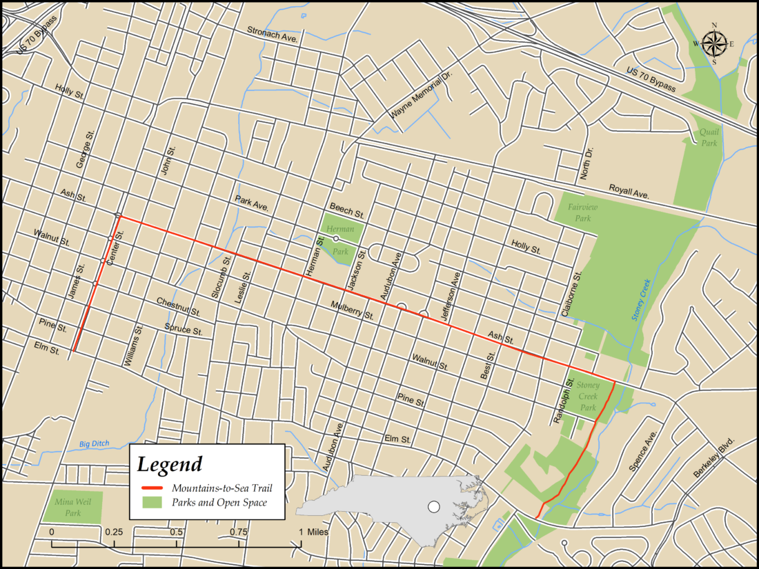
The 3.3 miles of designated MST route in Goldsboro include Center St. through downtown, a connection along Ash St., one of the city’s major thoroughfares, and the paved Stoney Creek Greenway.
Description
Beginning at the corner of Center and Elm Streets, head north through downtown on Center St., where several roundabouts feature public art. After 0.6 mile, at the roundabout with a jet honoring Goldsboro’s relationship with nearby Seymour Johnson Air Force Base, turn right on Ash St. Continue for 2.1 miles, past Herman Park, the Wayne County Public Library and several commercial and residential areas, then turn right into Stoney Creek Park.
At the back of the park’s parking lot, continue straight onto Stoney Creek Greenway, which extends 0.6 mile through a wooded area to Elm St., the end of the designated trail. From here, Elm St. provides a shorter route back to your starting point, but it is relatively heavily traveled and lacks sidewalks for much of its length, so returning the way you came may be the better option.
Kinston Riverwalk
This burgeoning food, art, and outdoor recreation destination features the Riverwalk, a half-mile-long greenway along the banks of the Neuse that connects several recreational, historical and cultural facilities.

Description
The Kinston Riverwalk begins near the corner of Herritage and King Streets, at the southern end of Tiffany West Park, which contains several military memorials. The path continues along the riverside past the Lenoir County Farmers Market. Just past the Farmers Market, a path on the right leads to the CSS Neuse II, a replica of a Confederate gunboat built and sunk during the Civil War.
Entering Pearson Park, the path turns away from the river. Meandering through the park, it passes a bandshell and playground, reaching its terminus at the end of Pollock St.
New Bern Riverwalk
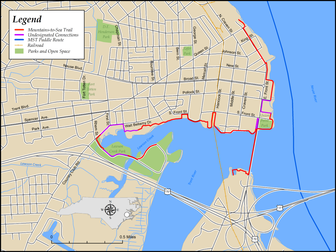
The former colonial capital of North Carolina has 3.1 miles of multi-use path designated as part of the MST. There are gaps in the designated trail, so an additional 0.9 mile of connectors, all on multi-use path and sidewalks, brings the total distance to 4.0 miles. The path skirts downtown and the Neuse and Trent riverfronts, passing several historic and scenic locations.
Description
The northern end of the Riverwalk is a short stub of multi-use path behind some houses at the corner of Queen and E. Front Streets. From here, follow sidewalks on E. Front St., past many large historic houses, for 0.3 mile, then turn left to follow a path along the water. In another 0.3 mile, in front of Persimmons Restaurant, make a short detour back to E. Front St. to go around the Courtyard by Marriott hotel, then return to the waterfront in Union Point Park.
After crossing under a road bridge at Mile 1.1, you reach a T-intersection, where you have two options. The shorter “spur” option is to turn right, then make a U-turn onto E. Front Street to cross the drawbridge over the Trent River. At the end of the bridge, turn right onto a pathway leading to the Bridgepointe hotel parking lot, then stay on the path near the river to its end. This spur is 0.7 mile one-way.
If you turn left instead, you continue along the Trent River waterfront for another 0.5 mile, where you will turn inland for about 150 yards to cross railroad tracks on the sidewalk of S. Front St., then immediately turn left to return to the river. After passing behind the North Carolina History Center and the back wall of the Tryon Palace grounds, turn left onto the sidewalk paralleling S. Front St., then left again as soon as possible to return to the river just past a water basin at Mile 2.0.
Continue on the path, staying near the river, for another 0.5 mile, then turn left on the sidewalk along Walt Bellamy Dr., then left again on First St. At Mile 2.8, turn left into the entrance to Lawson Creek Park. Follow the main driveway to a bridge over a small waterway, then turn left onto a narrow roadway near a parking lot and restrooms. Continue on this road for another 0.2 mile to a parking lot at the entrance to a marsh boardwalk. This is the end of the MST’s designated route in New Bern, Mile 3.3.
Morehead City
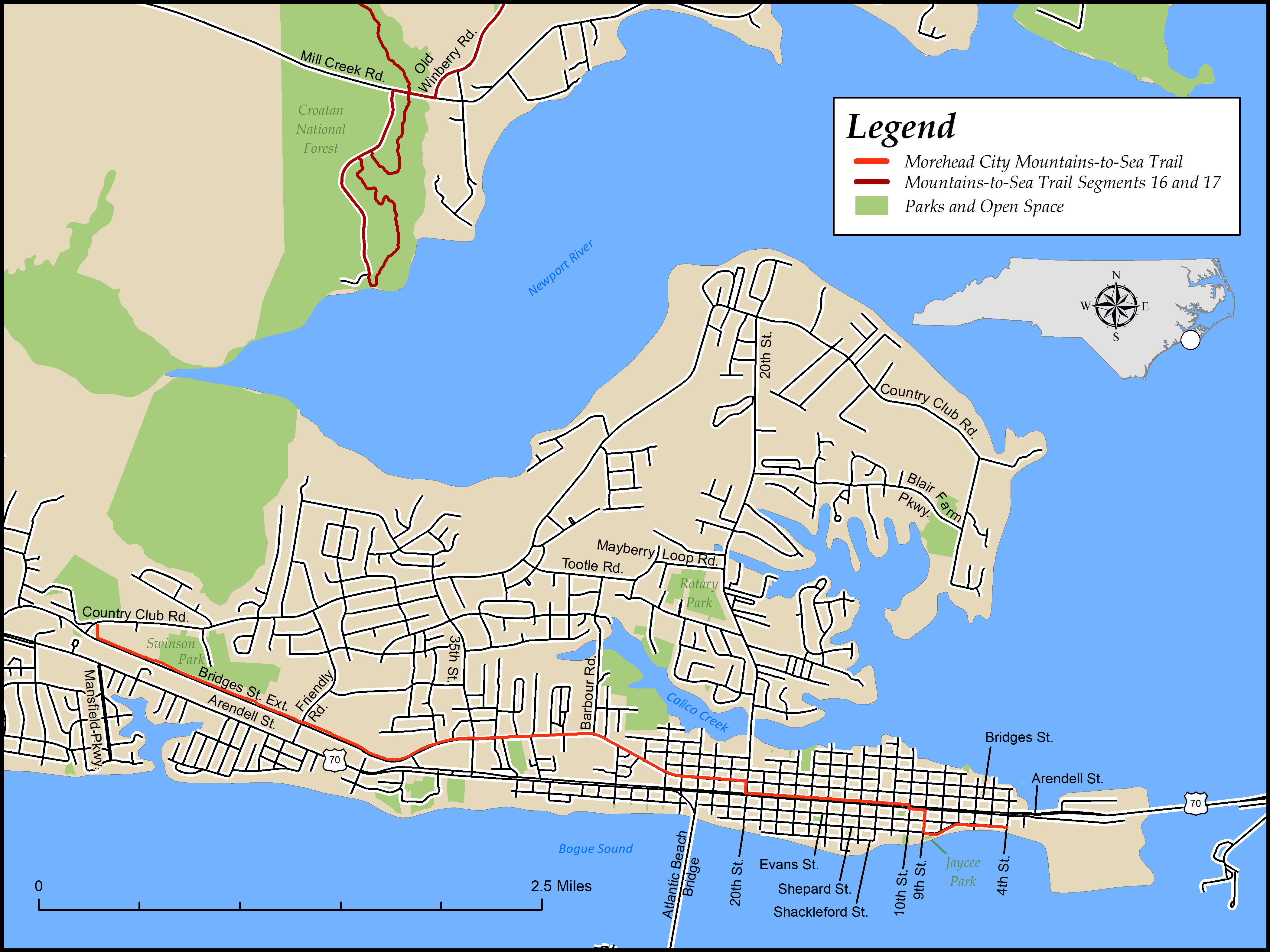
Morehead City boasts 5 miles of designated MST route, wandering along the downtown waterfront and commercial streets and through residential neighborhoods before joining Morehead City’s MATS Trail, formally known as the Morehead Alternative Transportation System, an asphalt and boardwalk multi-use path.
Description
Begin the Morehead City section of the MST near the eastern end of the waterfront promenade, heading west from the corner of 4th and Evans Sts.
In 0.3 mile, at a Y-intersection, turn left to stay on the promenade. At Jaycee Park, which features a fountain commemorating winners of the Big Rock Blue Marlin Tournament, bear right on the sidewalk paralleling Shepard St. At Mile 0.4, turn right on S. 9th St., then turn left on the south side of Arendell St. At 10th St., use the light to cross Arendell St. (your last protected opportunity) and continue on the north side. Continue for 0.9 mile, then turn right on N. 20th St. After one block, cross Bridges St. and turn left on the north side of the road.
At Mile 2.9, cross 35th St., where the path transitions from sidewalk to a wider multi-use path, the MATS Trail. In another 0.6 mile, just beyond the Carteret County Health Department, continue straight as the path becomes separated from the road by a chain-link fence. The trail here begins to take on a more suburban, and at times even rural, feel.
At Mile 4.3, pass a paved path on the right that leads to Swinson Park, which has public restrooms. In an open field just beyond the path are fitness and stretching stations, a picnic shelter and a water fountain.
At Mile 5.0, follow the path as it bears right away from Bridges St., then reach the end of the path and the MST’s Morehead City section at Country Club Rd. across from West Carteret High School.
