Day Hike 1: Beacon Heights to Boone Fork Parking Area
At the Foot of Grandfather (Mountain)
Distance: 8.1 miles
- Difficulty: Moderate. Rocky terrain in spots.
- Camping: Sites located in Grandfather Mountain State Park off Nuwati Trail, 7.8 miles into the hike. Permit required; call 1-877-722-6762 or visit www.reserveamerica.com and search for Grandfather Mtn. State Park.
- Land managers: N.C. Division of Parks and Recreation, National Park Service.
- Volunteer Task Force Leader: Randy Johnson, ranjohns@aol.com.
- Piggyback trail: Tanawha Trail.
- Connecting trails: Daniel Boone Scout Trail, Nuwati Trail.

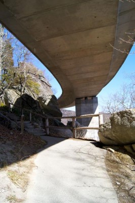
The Tanawha Trail, upon which the MST piggybacks from Beacon Heights to Price Lake, passes under the Linn Cove Viaduct.
What’s the difference between the top of Grandfather Mountain and its southeastern flank along the Blue Ridge Parkway? A lot during a “weather event.”
When weather moves into the region from the west, it moves in with a vengeance atop Grandfather, where the official wind gust record (sustained for three seconds) is 114.7 miles per hour, where 24 inches of snow have fallen in a 24-hour period, and where the temperature has dipped to 32 below and is typically 10 to 20 degrees cooler than the countryside below. Yet on its leeward southeastern flank, where the Mountains-to-Sea Trail rises from the Wilson Creek area back to the Blue Ridge Parkway, the weather can be civil even when it’s surly up top. And you’ll be able to enjoy a sampling of the rugged, rocky territory that dominates Grandfather’s crest. From Beacon Heights to Price Park, the MST piggybacks on the Tanawha Trail, which does a good job of taming the terrain with stone steps, artful bridges over dodgy creeks and the occasional ladder.
Plan to spend time in the Rough Ridge area, where the trail emerges into a fragile, exposed alpine environment (stay on the trail), offering some of the best 360-degree views on this stretch of the Mountains-to-Sea Trail.
View on Map
To see this hike on a map, visit our Interactive Map and click “Day Hikes” to view the endpoints.
Finding Your Way
| Finding Your Way (west » east) | Mileage |
|---|---|
| Trailhead: Beacon Heights parking area. To begin the hike, cross the paved road and follow signs to Beacon Heights Trail, heading into the woods. | 0.0 |
| At intersection with Tanawha Trail, which runs conjunctively with MST for the next 13 miles of this segment, turn left (north). | 0.1 |
| Cross US 221. | 0.4 |
| Ascend to area with large boulders. Hike on boardwalk next to stone parkway retainer wall. Leave boulder field. | 0.5 |
| Ascend steps. Trail forks. MST goes right. Stack Rock parking area (MP 304.8) is 90 feet to left. | 0.9 |
| Ascend and then descend on wooden stairway and boardwalk that goes around giant rock formation known as Stack Rock. | 1.1 |
| Cross bridge over Stack Rock Creek and pass waterfall. | 1.2 |
| Ascend wooden and stone steps. (This section is strenuous.) | 1.3 |
| Pass storage buildings on left. | 1.5 |
| At Linn Cove Visitor Center (MP 304.4), follow paved path around outside of parking lot. | 1.6 |
| Pass Linn Cove Viaduct sign. | 1.7 |
| Pass under viaduct and follow steps through large boulders to continue on MST/Tanawha Trail. | 1.9 |
| Cross bridge over Linn Cove Branch. | 2.0 |
| A side trail goes to right 60 feet to rock outcrop with good views of viaduct, Table Rock, Hawksbill, and Pisgah Forest. | 2.2 |
| Cross footbridge. | 2.5 |
| Pass Balanced Rock on right. | 2.8 |
| Trail to Wilson Creek Overlook (MP 303.6) is on right. Continue left and cross bridge over Wilson Creek. | 2.9 |
| Side trail on right goes to rock outcrop with good views. Continue left on main trail. | 3.8 |
| Walk on Rough Ridge boardwalk. | 4.2 |
| Trail to Rough Ridge parking area (MP 302.8) goes right. | 4.4 |
| Cross Little Wilson Creek on arched footbridge. | 4.6 |
| Side trail on right leads to Boulder Fields Overlook parking area (MP 302.4) but stay left. | 5.1 |
| Cross footbridge. | 6.6 |
| Daniel Boone Scout Trail goes left. Continue straight on main trail. | 7.6 |
| Nuwati Trail goes to left. Stay right for MST. | 7.8 |
| Asutsi Trail goes right for 0.4 mile to US 221 (winter parking when BRP is closed). Cross Upper Boone Fork bridge to stay on MST. Upper Boone Fork Trail goes right 0.5 mile to Calloway Peak Overlook (MP 299.7). Continue left for MST. | 8.0 |
| Trailhead: Boone Fork parking area (MP 299.9) is 400 feet to right. | 8.1 |


