

Over 45% of the Mountains-to-Sea Trail has reopened in the mountains following Hurricane Helene. So much incredible work has been done by the staffs of the National Park Service and the US Forest Service, contractors and MST volunteers to get nearly half of the trail cleared and safe for hikers. This has been an all-hands-on-deck collaboration across agencies and volunteer crews to tackle the unprecedented damage that Hurricane Helene caused. While we still have over half of the trail to reopen, and that will be the harder half, we’re grateful and humbled by the work that has been done.
In the first weeks and months after the storm, a tremendous amount of work was done by National Park Service and US Forest Service staffs. For liability reasons, these pros assessed the trail first and found that much of the damage was beyond even their training.
Skilled professional crews and contractors were brought in to detangle the massive tree pile ups and create a narrow corridor of the trail route, oftentimes needing GPS to find the trail. Once the first pass was cut and areas were deemed safe for volunteers, our crews got to work.
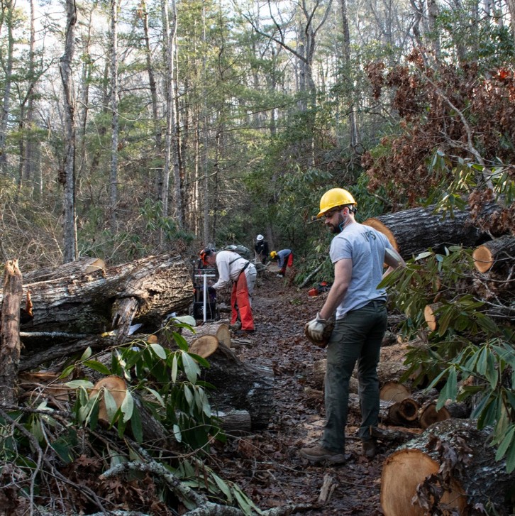
Carolina Mountain Club, in partnership with the Blue Ridge Parkway and Friends of the MST, led a weeklong work blitz through the MST Asheville corridor, with Friends of the MST volunteers coming from as far as Ohio and our Croatan Task Force. CMC provides trail work and advocacy for the MST and other trails throughout the western part of NC and, along with our other task forces, has been instrumental in pushing for trails to reopen.
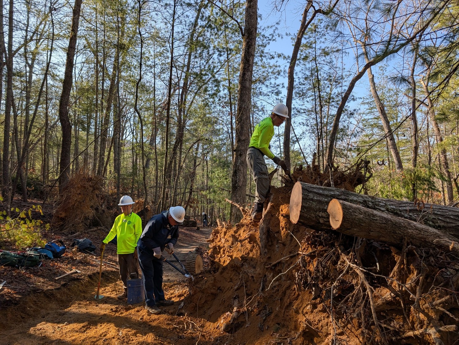
The Central Blue Ridge Task force has been steadily working through the Linville Gorge section with weekly workdays, with upwards of 35 volunteers out some days. As a result, 80% of the MST in that area has reopened. Elkin Valley Trails Association has just gotten the trail reopened through Stone Mountain. That is the good news.
Now to the less good news, as we begin to think in terms of work that will take months and years. Friends of the MST has been working with land managers and others to compile an updated map of trail conditions, including what is open, closed and uncertain. Click here to access the map. The map below is a screenshot taken March 25, 2025.
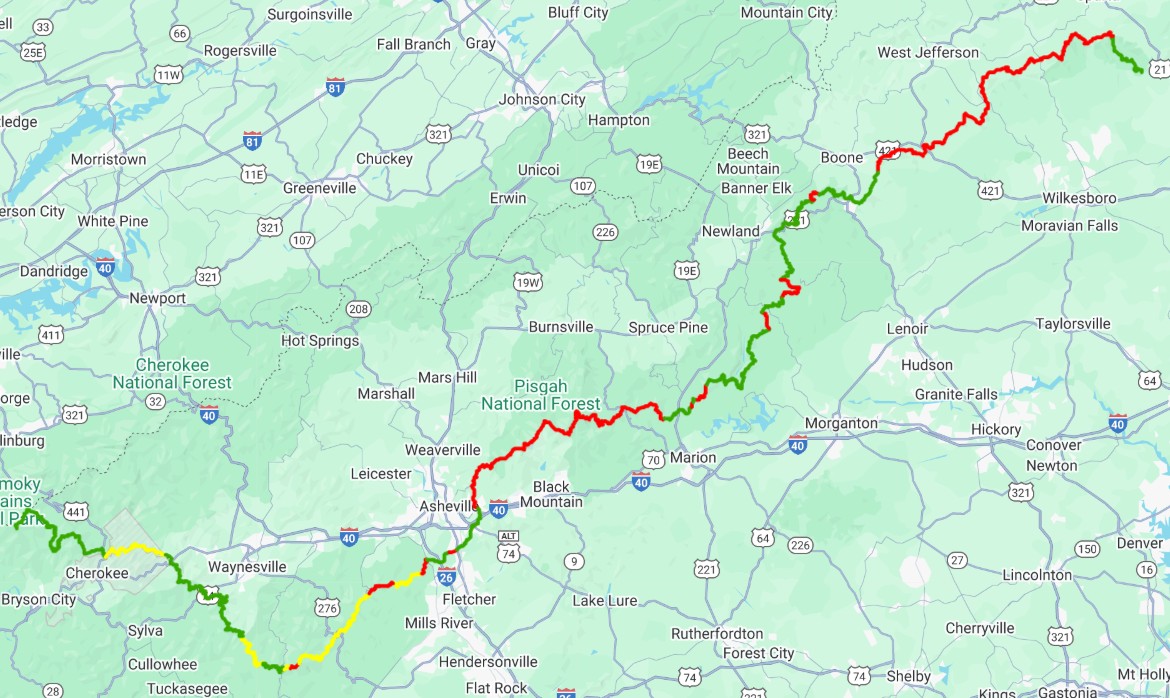
Green represents trail that has been opened by the land manager and we have on the ground reports that it is safe for hikers. Yellow is trail through land that has been opened by the land manager but we haven’t yet had eyes on the ground reports about the trail conditions. Red is closed by the land manager and off limits. And keep in mind that where the Blue Ridge Parkway is closed it is closed for everything – ALL recreation, hiking, and volunteer trail work.
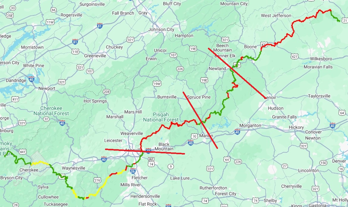
To help understand the recovery, it’s easiest to divide the mountains into four large sections. The first section is from the terminus at Kuwohi to Asheville, second is from Asheville to near Marion, third from Marion to Beacon Heights near Grandfather Mountain, and then from Beacon Heights to Stone Mountain State Park.
Kuwohi to Asheville
From the western terminus to approximately milepost 44 on the Blue Ridge Parkway in segment 2, the trail looks good as the storm wasn’t as impactful further west. Once in the Devil’s Courthouse area near milepost 44, there begin to be closures on the parkway. A couple of these have somewhat easy short-term reroutes, that we are working to get approval for, and in other locations, the parkway has prioritized road reconstruction. Several of these projects are already underway around Asheville and just north of the Folk Art Center. Superintendent Tracy Swartout, Trails Coordinator Neal Wilcox, Landscape Architect Jeff Curtis and Volunteer Coordinator Jonathan Bennett have been outstanding in their work on behalf of the MST.
Asheville to Near Marion
Further north, between Craven Gap and Mount Mitchell, there is a long stretch of red. There are two landslides on either side of Mount Mitchell that will require significant infrastructure to rebuild the roadbed. State Parks is working with the National Park Service on a time frame to restore access to Mount Mitchell State Park, but it will be lengthy. In this long stretch of closed trail, the footpath is buried under huge hardwood tree pile ups in areas where it is routed high on the ridges. In other spots, the tree cover is mostly smaller trees like birch and beech and didn’t suffer the catastrophic and widespread type of damage, so the trail appears to be in better condition, but it is not accessible because of the landslides.
Based on what we know from the land managers, it appears likely that the MST could remain closed here from approximately I-40 to either NC 80 or US 221 for upwards of 3 years. Our goal is to create convenient access points for thru hikers to shuttle around, and we are finalizing that guidance soon.
Marion to Beacon Heights
Moving on to the next section through Linville Gorge from approximately US 221 to Beacon Heights near Linn Cove Viaduct and Grandfather Mountain. More than 80% of the MST has reopened due to the strong partnership with the US Forest Service under the leadership of Lisa Jennings, the nonprofit contractor Wild South and Friends of the MST’s Central Blue Ridge Task Force.
The nearly 200-foot bridge over the North Fork of the Catawba River was lost, and the US Forest Service is exploring options to replace that. One half of the steel bridge traveled a short distance before lodging itself on the riverbed and the other went much farther downriver, scooting under a railroad bridge without damaging it. Forest Service staff and Wild South plan a temporary wet crossing location that will help hikers cross the river until a replacement bridge can be built.
There are plans to clear the remaining closed areas with most to be reopened by summer. Those areas that are longer-term closures can be avoided by accessing nearby trails.
Beacon Heights to Stone Mountain State Park
Moving on to the northern mountain section, the MST comes out of Linville Gorge and again follows the Blue Ridge Parkway from Beacon Heights to where the trail drops off the parkway into Stone Mountain State Park.
Task forces in the Grandfather Mountain and the Tanawha Trail area, and a short portion of the trail in Watauga County around the Boone area, have cleared much of the trail and it is easily passable. Julian Price Park is still closed, and we haven’t received an update there from the National Park Service. The campground should open for the summer, but the trail still remains closed.
There is a very long closed stretch coming up from the Boone area all the way to Devil’s Garden Overlook where the trail then joins into Stone Mountain State Park. This stretch is closed because of on-going roadbed reconstruction and paving. In the past, volunteers could access the trail from side roads or walk in. This wasn’t ideal, especially for sawyers carrying heavy gear, but in most cases it was feasible. And hikers were allowed to walk the trail.
Now, with the new enforcement of “any closure on the parkway is a 100% closure,” our volunteers have not been able to do trail work since the hurricane. In early February, we began negotiations to allow our trail volunteers in by coordinating with the paving contractors’ schedules. Our crews have been admirably patient but are frustrated because they take much personal pride in keeping the trails safe and beautiful for all to use. It’s been a long time off the trail, and the trail needs their attention. We can safely assume that the trail is degrading through this area and will need much work to return it to good shape.
As we finish up the mountain section, the MST has been fully cleared and reopened through Stone Mountain State Park.
The National Park Service and US Forest Service have had significant reductions in staff, which has the potential to hamper and delay trail recovery efforts in these areas. Amid the ongoing uncertainty around staffing at federal agencies, we will continue to support our agency partners as they move forward and our organization, from staff to volunteers, stands ready to pitch in where we can to ensure the path to recovery for the MST, and other trails and facilities across the mountains, remains a priority.
We remain optimistic and cannot stress enough the work we’ve put into the relationships with these hardworking champions of the trail and the work that they have put in on our behalf.
Associate Director Betsy Brown is overseeing hurricane recovery and is in constant communication with our mountain partners, task force leaders and other nonprofit and trail groups. While it may seem like a slow process, the amount of work, planning and energy going on is thoughtful and complex. In time, the MST will reopen more sustainably and with additional amenities. Until then, we invite you to explore the trail in open mountain areas and support those communities as they get back to business. Jim Grode and Betsy Brown are working on guidance for those who wish to complete the MST, and should have that ready in the next few weeks.
We wish we could give you a timeline, next steps and a reopen date. Some of the MST may be closed for a few years, some may reopen sooner. In the meantime, check the map for the most updated trail information, reach out if you have specific questions and we’ll do what we can to get the answers. In the meantime, there are many miles of MST to explore in the Piedmont and the Coastal Plain.
And when we are allowed back on the trail, whether it’s next month or next year, we’ll need the MST Community to show up, as we know you will.
