

What is Fish Dam Road?
Historic Fish Dam Road was originally an American Indian trading path connecting Occaneechi Town, located in a sharp bend of the Eno River in today’s Hillsborough, with a related village on the Neuse River. The path also connected local villages with the Great Trading Path, which ran from present-day Petersburg, VA, to Augusta, GA, and was the primary travel route across the North Carolina Piedmont.
Members of the Adshusheer, Occaneechi, Sissipahaw, and Saxapahaw tribes used the path to trade among themselves and later with Europeans. Native villages mainly traded deer hides for European trade goods like brass bells and buckles, knives, glass beads and clay pipes. In the mid to late 1700s, when Europeans settled the area, the footpath became a wagon road. It was named after a fish dam, or weir, in the Neuse River near the Cheek Road end of Fish Dam Road. A fish dam or weir is a funnel-shaped obstruction, typically made of stone or wood, that forces fish into a narrow channel where they can be easily netted or speared.
During the Civil War in April 1865, Fish Dam Road was likely the route Confederate General Joseph E. Johnston took to meet General William T. Sherman at the nearby Bennett Farm. Now known as Bennett Place State Historic Site, it was the site of the largest surrender of the Civil War, which effectively ended the war. According to the Scarlett family, generations-long residents of the area, soldiers in search of food and valuables raided farms along the road. Local residents walked pigs, cows, and other livestock down Fish Dam Road and secreted them near the cooling waters of the Eno so they would not be killed and consumed by hungry soldiers. As many personal keepsakes as one could collect were hidden out of view of the soldiers.
Throughout the 1800s, Fish Dam was the only major road connecting Raleigh and Hillsborough. It had its own postal route until the early 1920s. When the straighter National Highway—later called Highway 10, then U.S. 70—came through, Fish Dam Road was abandoned and reclaimed by nature.
What Is the Mountains-to-Sea State Trail?
The Mountains-to-Sea State Trail, or MST, is primarily a hiking trail that is a unit of the North Carolina State Parks system. Ultimately, it will stretch 1,400 miles along two routes from Clingmans Dome, the highest point in Great Smoky Mountains National Park, to Jockey’s Ridge, the largest and highest living sand dune on the east coast. In between, it passes through many of the diverse natural areas, agricultural fields and towns that make North Carolina special. Currently, over 700 miles of natural surface or paved off-road trail are part of the MST, while a series of connectors on back roads knits together finished trail sections to span the state.
Caution
Over most of the historic route of Fish Dam Road, there are no remaining traces of the road, and no trail follows the route. We do not recommend leaving officially designated trails or trying to hike the FDR route.
If you experience an emergency, please call 911 and give them the location information described below for your nearest crossing.
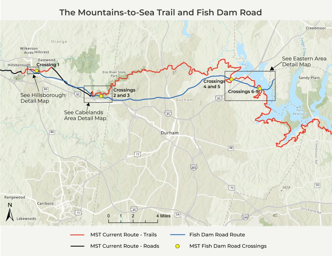
Fish Dam Road Crossings
The Mountains-to-Sea Trail (MST) crosses Fish Dam Road nine times between Hillsborough, just east of the replica Occaneechi Village, and Cheek Road near Falls Lake in Durham County (parts of Segments 9 and 10 on the MST).
From west to east, the crossings are as follows (except as noted, directions are for the eastbound MST):
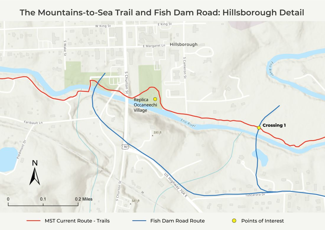
Crossing 1
An easily visible remnant of historic Fish Dam Road crosses under a bridge on the MST on the Hillsborough Riverwalk (Segment 9) about 300 yards east of the Occaneechi Village Replica. An interpretive sign here describes ancient roads and travel for Indigenous people, colonial traders, and residents before automobiles. Hillsborough was a major town in the Piedmont during the colonial period, with a tavern, stagecoach, courthouse, political activity, and connections to major trade paths.
911 Information: Near Burnside Dr., Hillsborough, NC 27278
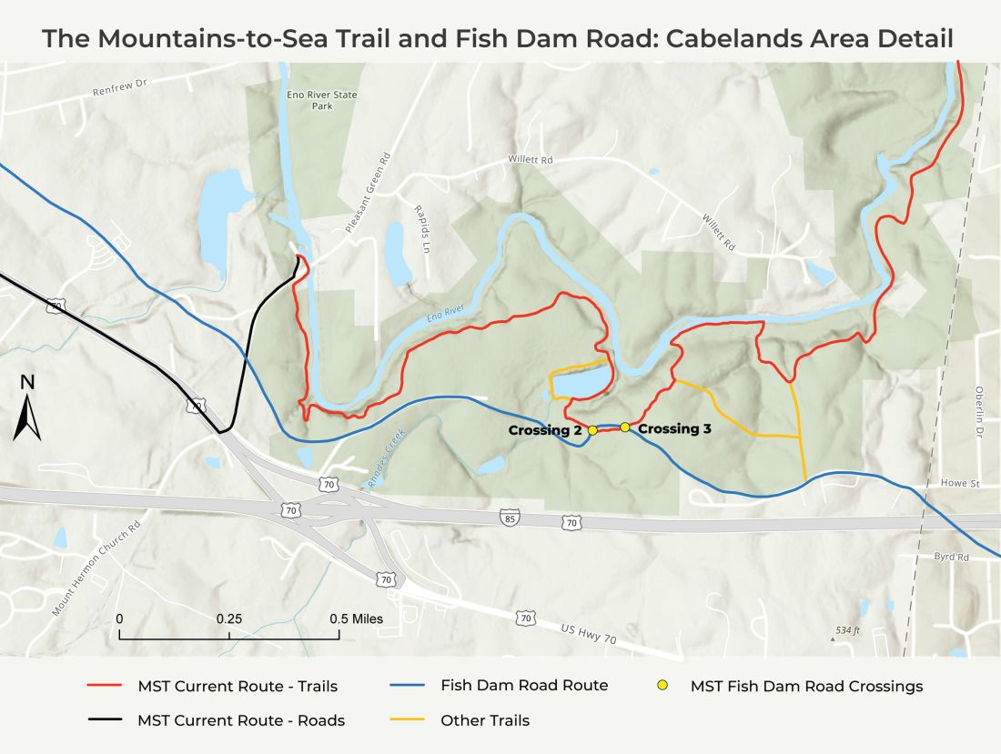
Crossing 2
The MST crosses remnants of FDR about 1.7 miles east of Eno River State Park Pleasant Green Access parking area, 4770 Pleasant Green Rd., Durham, NC 27705. Beyond the Eno Quarry, the MST bears left across Rhodes Creek and begins climbing. Approximately 200 yards farther, just after the trail flattens out, is a slight dip in the trail with visible depressions on either side—the old bed of Fish Dam Road.
Crossing 3
About 130 yards east and slightly uphill of Crossing 2, there are four wooden steps on the MST. At the base of the steps is the bed of historic Fish Dam Road, which is visible extending both left and right. Between the MST and FDR on the right (eastbound), another depression marks the remains of the old Cabe Mill access road, abandoned in the early 1900s.
911 Information: Crossings 2 and 3 are on the Quarry Trail in Eno River State Park. If you are experiencing a law enforcement or medical emergency, call 911 or the State Ranger Direct Line (919) 616-2959. The closest parking lot to these locations is the Cabelands Access located at 4950 Howe St., Durham, NC.
North Carolina State Parks Rules and Regulations can be accessed at this site: NC State Parks Rules and Regulations | NC State Parks (ncparks.gov)
Please call the park office at (984) 250-1370 with questions or to report a blocked trail.
Crossing 4
The next place the MST crosses Fish Dam Road is east of Red Mill Road, near the north bank of Ellerbe Creek at the base of an electrical tower by an electrical substation. Although the old FDR is not apparent at the actual trail crossing, there are visible traces just down the hill on both sides of the lake. Before being flooded by Falls Lake, Ellerbe Creek was a shallow creek with accommodating banks for travelers and wagons to ford the creek, but the ford is now underwater. The historic FDR forded Ellerbe Creek and climbed up to the current tracks of the Norfolk Southern Railroad, continuing east.
911 Information: North of 4250 Red Mill Rd., Durham, NC 27704
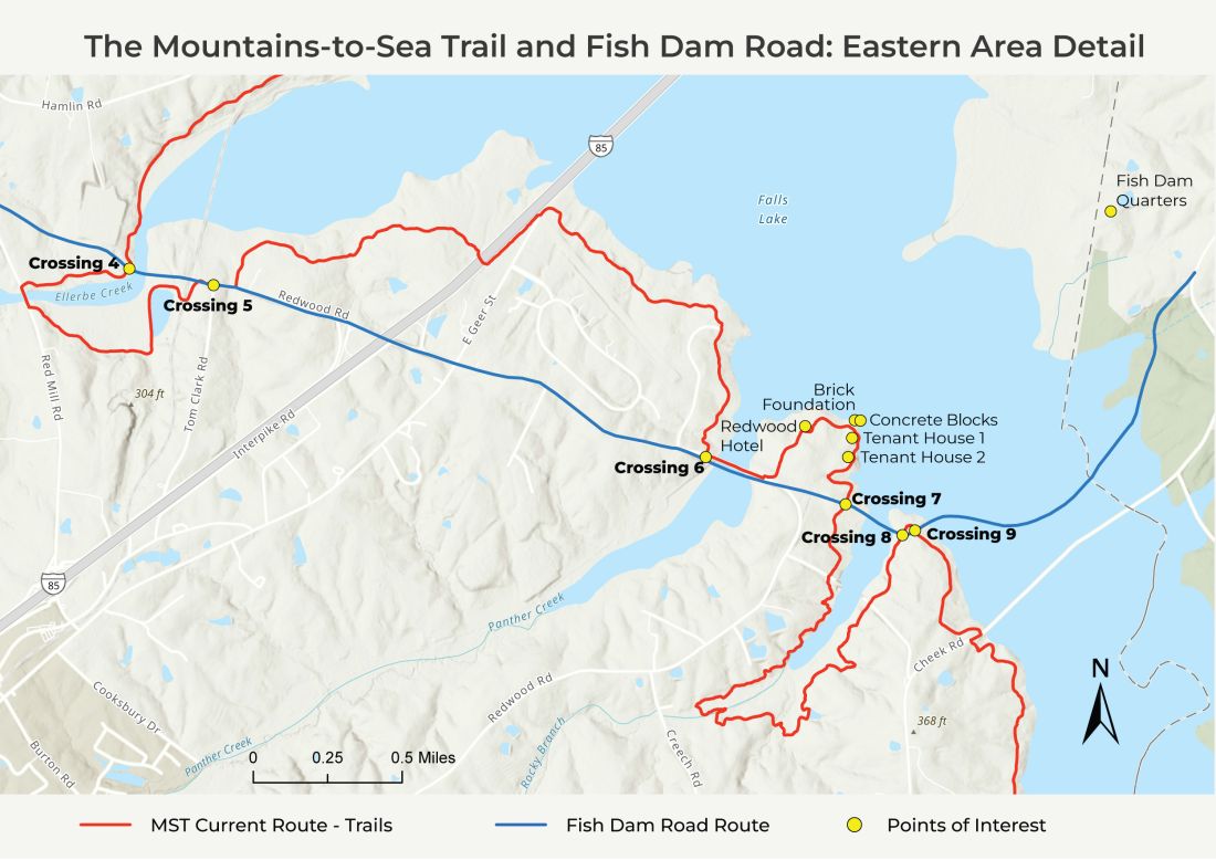
Crossing 5
Near the intersection of Tom Clark Road and Redwood Road (3321 Tom Clark Rd., Durham NC 27704), the MST footpath follows historic FDR for about 25 yards beginning at a kiosk just west of Redwood Road. The MST and FDR continue together on Redwood Road for another 100 yards until the MST turns off onto trail again, while the historic FDR route continues on Redwood Road until just before it reaches Hereford Road, about 1.9 miles.
911 Information: Near 3321 Tom Clark Rd., Durham NC 27704
Crossing 6
Although they technically do not cross, FDR is within a few feet of the MST at the western end of the crossing of the Panther Creek arm of Falls Lake (4530 Redwood Rd., Durham, NC 27704). The deep gully behind the kiosk south of Redwood Road is one of the best-preserved remnants of the old roadbed. Going east, FDR continues just south of Redwood Road down to and under the lake. On the other side of the crossing, the MST turns north off the road, while Redwood Road and FDR continue together for a few yards until Redwood makes a sharp right and FDR continues straight into woods and fields.
911 Information: Near 4530 Redwood Rd., Durham, NC 27704
Crossing 7
Further east, as the MST heads south toward Hereford Road, FDR Crossing 7 is evident as a depression between steep banks, leading west to a field and then Redwood Road, and east toward the lake.
911 Information: North of 540 Hereford Rd., Durham, NC 27704
Historical Points of Interest Between Crossings 6 and 7
Beyond Crossing 6, on the east side of Panther Creek, the MST heads north towards the historic ruins of Redwood Hotel. This 2-story structure possibly operated as a tavern, serving FDR travelers and as a stop on the Durham and Northern Railroad from the late 1890s to 1930s, when auto travel became the norm. A local resident, David Glenn, tells of walking through the hotel ruins as late as the 1960s. The hotel was likely demolished in the 1970s by the Army Corps of Engineers when the property was purchased for the construction of Falls Lake. All that remains is the chimney and a few pieces of the foundation. About where the present MST campsites are located was where the hotel stables accommodated travelers’ horses.
Also in the area is a cemetery suspected to contain graves of enslaved people from Fish Dam Quarters, one of 10 quarters, or communities, of enslaved people who tended the plantations of the Cameron family. The Camerons controlled several plantations totaling about 30,000 acres, including what is now the Historic Stagville State Historic Site, and exploited the labor of over 1,000 enslaved people to become one of the wealthiest families in antebellum North Carolina. (From near Penny’s Bend Preserve to the Little Lick Creek crossing, 24.5 miles, the MST is located on land that was previously part of the Cameron plantations, and Crossings 4-9 are located on former plantation lands.)
Further east off the MST and on the peninsula are remains of a brick foundation and two large concrete blocks, likely part of the Neuse Lumber Company sawmill that operated 1908-10 and was demolished and removed in 1917. Remnants of two tenant houses are uphill on the side of the trail away from the lake. The houses are easily found in the winter but may be difficult to see in the summer. In the larger house, some of the old wallpaper is still visible.
Crossing 8
The MST continues to Hereford Road, where a causeway over Rocky Branch was removed in 2023, then follows a 1.9-mile loop up Rocky Branch and back to Hereford Road. Approximately 0.3 mile beyond the second Hereford Road crossing (510 Hereford Rd., Durham, NC 27704), east of Rocky Branch, is FDR Crossing 8, featuring well-preserved remnants of the road both west (down to the lakeshore) and east (uphill into briers). Like other remnants, the roadbed is marked by a depression in the trail. In a short distance the MST bears right and the next crossing is soon visible.
911 Information: North of 510 Hereford Rd., Durham, NC 27704
Crossing 9
Crossing 9 is marked by a large pine tree in the path. To the west, FDR is nearly invisible. To the east, it remains a little more defined, but quickly goes into thick underbrush as it slopes down into the lake. FDR would have headed north across the Neuse River, possibly near the fish dam in the original channel of the Neuse River, to Fish Dam Quarters on the north shore near Cheek Road and Old Weaver Trail.
911 Information: North of 510 Hereford Rd., Durham, NC 27704
Sources and Further Reading
- In 2004, Joe Liles walked and researched Fish Dam Road with his students from the NC School of Science and Math. They studied the road from Hillsborough all the way to the Fish Dam Quarters of the Cameron Fish Dam Plantation near Cheek Road and Old Weaver Trail. Much of this description is based on his research and writings.
- Beverly Scarlett, Ribbons of Color Along the Eno River, Eno Journal Vol. 10, No. 1, 2021, & No. 2, 2022, © Eno River Association (description of life along the Eno River for the Occaneechi Band of the Saponi Nation, and travel along the Great Trading Path and Fish Dam Road)
- Jay “Greybeard” Schwantes, Cabe Lands Area page of Eno Trails.com, http://enotrails.com/quarry-trail.htm (2011-2023).
- Jerry Barker Interview with Vera Cecelski, Site Manager, Stagville Plantation State Historic Site, Dec 21, 2022.
- https://www.enoriver.org/year-of-the-trail-feature-cabelands.
- https://historicsites.nc.gov/all-sites/historic-stagville.
